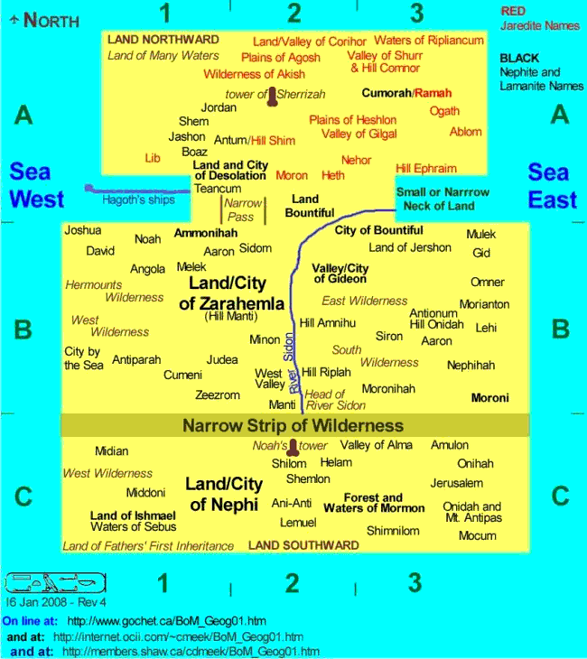
The map is adapted from a map by Joel Hardy from March of
1998, with revisions to 2005 (see original).
Joel's geography web page also provides
some comparisons and other maps that relate in some ways to
present day geography.
His MormonHaven.com
website contains a tonne of current, reliable information
concerning the Church of Jesus Christ of
Latter-day Saints.
By using a generic map on which to locate place names, we focus here on geographic information provided in the scriptures. The intent is to show some sense of conceivable and plausible locations and relationships between places and the key features: the narrow neck of land (delineating the land northward and land southward), the narrow strip of wilderness (which ran from the east even to the sea west), and the oceans/seashores. This generic approach allows us to avoid being bogged down with relating either places or features to any present-day geography (significant changes to which occurred at the Savior's advent among the Nephites as described in 3 Nephi 8:11-12, 4 Nephi 1:9, and elsewhere). We also wanted to provide a map in a form that could be printed in sizes that will fit in typical bound scriptures.
This effort also provides:
Below is the generic map that will likely fit on your screen. Click on the image to open a new window and display a full-sized map. See below for further information and suggestions in its use.

Here are some notes and suggestions about viewing and printing this map.

 .
.
If you click on the above image, your browser opens a new window
and displays the map by itself, with no words, etc.
If your full-sized image looks like the map fragment to the left, and your mouse pointer looks like the (+) symbol in a circle, then click that to give you a full-sized version that will look more like the fragment to the right. If you are using Microsoft Internet Explorer browser, and when you run your mouse over the lower right of the map image, you see the enlargement icon (a screen with four blue arrows pointing outwards on the diagonals), then click that for a full-sized version. The 650 x 688 pixel version prints on an 8 1/2 by 11 inch page in my system. In either case, you may have to scroll up and down (and maybe left-to-right) to see the whole map on your screen. But the lettering will be much more readable. If you print the more readable one, it will likely fit on an 8 1/2 by 11 inch page.
Here are a selection of sizes that may be helpful, or more suitable for printing. At each size, the .JPG requires much more file space, and will take much longer to download. To my eye, the .JPG quality is not any better. I therefore recommend the .GIF format in every size. If you decide to re-size to your own dimensions, pick the largest size, and re-size that. Re-sizing downwards always produces a better result than re-sizing upwards. All these files will open a new window in your web browser. To return here, just close the new window.
 .. [Return Top||Bottom] ..